
Trace a Hillside Street
Address work in Hillside should move from the physical parcel to the names in the records, not the other way around. USPS helps standardize the delivery address. The State property route and Union County GIS then provide the parcel context. Record the Hillside Township, Union County, block, lot, and situs address before opening a name-based deed search. That sequence prevents a common surname from pulling the research onto the wrong street.
Ownership and residency are not the same thing. A tax list may name an assessed owner. A deed may name a grantor or grantee. A voter record can concern registration status. A historical directory may show an occupant in a specific year. The Hillside street directory works best when each source is dated and its narrow purpose is stated.
- Run the street address through USPS, then locate the Hillside parcel in Property Explorer or Union GIS.
- Write down the block, lot, parcel geometry, and current situs before looking for a person.
- Use the assessed owner or recorded deed party in the Union County Clerk name index.
- Match the legal description, date, and party role before moving backward through deeds.
- Use a historical reverse directory or local newspaper only for the relevant past year.
Hillside Street Address Keys
Hillside is in Union County and uses New Jersey block, lot, qualification, and parcel conventions. A street number alone is not the strongest property key. The County GIS can locate a segment and identify a parcel, while the Hillside assessor keeps property cards and the township tax map. The State Property Explorer is the public starting point for address, county, municipality, block, and lot searches.
The situs address is the location of the parcel. A mailing address is the tax-correspondence destination and can belong to an owner outside Hillside, a trust, or an entity. Treat a mailing address as a contact clue, never as proof that a person lives on the street. A deed’s legal description is the land description that links the title record back to the right block and lot.
- Parcel
- A mapped tax unit that may contain a building or land.
- Situs
- The location of the parcel on the street.
- Block and lot
- Local tax identifiers used to match assessment and map records.
- Legal description
- The deed’s formal land description, which may not use a current street number.
Hillside Street Property Fields
The New Jersey Property Explorer supports address, county, municipality, block, and lot. Tax-list information may include the location, owner information, block and lot, annual land and building assessment, prior-year taxes, and classification. The State describes the data as an annual January filing snapshot. A recent sale or improvement can therefore appear later than the current deed or permit record.
The Hillside assessor page says the office maintains property cards by block and lot and the township tax map, processes added assessments from building permits, and administers certain exemptions and deductions. The official municipal page did not supply a public Hillside owner-name form. For owner-name confirmation or local-card detail, contact the assessor rather than assuming an unofficial form has the same fields.
| Search field | Use for a Hillside street |
|---|---|
| Street address | Locate the parcel after USPS standardization. |
| County | Select Union County in the statewide route. |
| Municipality | Select Hillside Township. |
| Block and lot | Confirm a parcel where a street name is ambiguous. |
| Qualification/PIN | Use where the result supplies a local parcel identifier. |
| Owner name | Use the assessor or tax-list route; a live Hillside online field was not verified. |
Review the Property Explorer search route before entering an address.
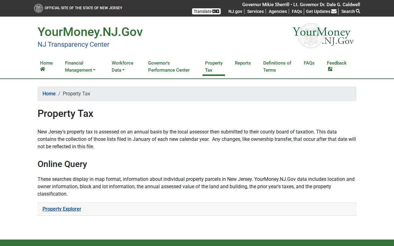
The returned property fields give an address researcher a parcel anchor, not a complete list of street occupants.
Hillside Street GIS View
The Union County GIS viewer is useful for browsing a street segment and adjacent parcel geometry. After accepting its general-reference disclaimer, search an address, turn on the parcel layer, zoom and pan along the street, and use the identify tool for parcel attributes. Zoning, flood, and district layers add context but are not title evidence or a legal survey.
Use a map click to record the parcel and nearby geometry. Then check block and lot with Property Explorer or the assessor before linking a person to it. The State NJGIN parcel service can redact owner names under Daniel’s Law. A blank owner field can be a deliberate privacy protection, not a sign that the parcel lacks an owner. The correct next step is the local custodian or Clerk, not an unsupported guess.
Note: The GIS measure and identify tools orient a Hillside street search but do not establish legal boundaries or a common-owner relationship.
Hillside Street Deed Chain
The Union County Clerk name index has no inspected street-address field. Translate the Hillside address into an owner and legal description first. The name form requires a last name, date range, party type, and one or more document types. It also offers exact, starts-with, and Soundex surname modes. Search a current owner as grantee for an acquisition, read the prior grantor and legal description, then search that grantor as an earlier grantee.
Online official land records begin June 1, 1977, but the Clerk says the record room holds Union County land transactions from 1857 to the present. Older online images can be incomplete because pre-January 1986 imaging remains in progress. An index hit without an image still supplies an instrument number, document type, recording date, and sometimes book/page information for a record-room or copy request.
The grantor-grantee search screen shows the party, date, and document controls used to turn a street parcel into a recorded title trail.
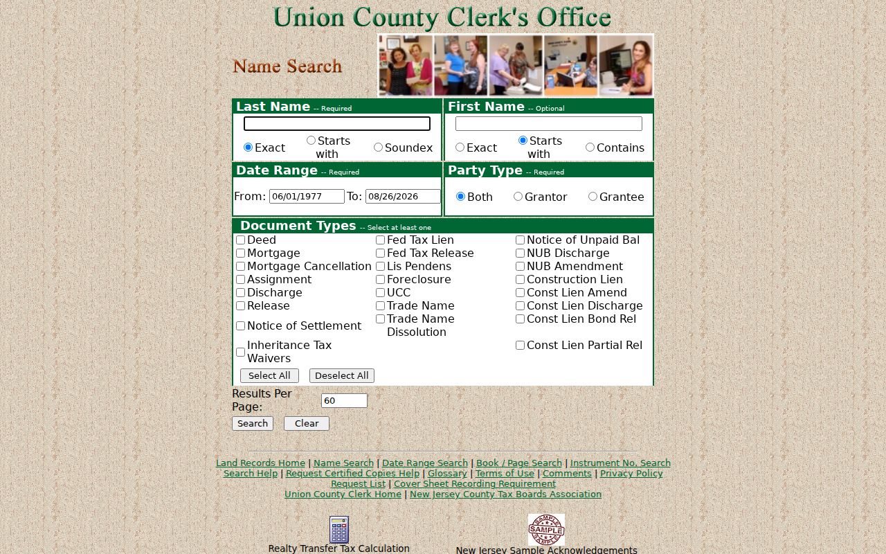
Keep the parcel match beside every result, because a name match alone does not prove that the instrument concerns the Hillside street address.
Note: The Clerk’s certified-copy route uses an online request list or mail order and lists $8 for the first page plus $2 for each additional page per copy.
Hillside Address Permit Requests
Hillside Building and Housing maintains construction-permit, inspection, certificate, vacant-property, and code-enforcement routes. Its official public page does not expose a searchable permit or case index. A focused request is the reliable access channel: give the street address, block and lot, record category, and date range. Ask whether a requested public portion is available and whether protected information needs redaction.
Permit, certificate of continued occupancy, habitability, vacant-property, and code records can date work at an address or identify an applicant, contractor, agent, or owner. They do not establish every resident. A permit applicant may be acting for the property owner. The department lists inspection-request forms and its 1409 Liberty Avenue location, while OPRA is the written fallback for records held by another municipal custodian.
Hillside Historical Street Entries
For an earlier address, the numerical or criss-cross portion of a historical directory is the Hillside street directory layer. Search the street name and number, then read the occupant entry exactly as printed. Hillside can be filed under a regional Elizabeth or Union County heading. A published abbreviation key may distinguish a private residence, business, widow notation, or other status, so read the key in that volume rather than assigning a meaning from a later book.
Hillside Public Library links its catalog, Ask a Librarian service, and Digifind newspapers. Verified regional and Hillside-inclusive directory years are discrete, not a continuous annual run. The Hillside city directories page has the collection detail. Use the directory year with deeds, census, and Hillside Times notices rather than treating one listing as proof of a move date or household composition.
Hillside Street Record Sources
Address-keyed sources answer different questions along the same street. Property records identify the parcel and assessed owner. GIS maps show geometry. The land index supplies recorded parties and title clues. Building records can date work. The voter-status portal is person-centered, not a public street browse, and full voter-list access goes through the Union County Board of Elections under applicable election and privacy rules.
| Record set | What it can show | Hillside access channel |
|---|---|---|
| Property card and tax list | Assessed owner, parcel, situs, assessment data | Assessor, Property Explorer, tax map |
| GIS parcel layer | Parcel geometry, adjacent lots, mapped street | Union GIS viewer |
| Deed and mortgage index | Recorded parties, type, date, instrument | Clerk online index, record room |
| Deed image or copy | Legal description and prior-reference clues | Published image, Clerk request, archives |
| Permit or code file | Work, inspection, certificate, applicant clue | Building Department or OPRA request |
| Reverse directory | Historical address-to-occupant entry | Library, catalog, archival collection |
The Clerk’s book/page search is useful once an earlier deed supplies those reference numbers.
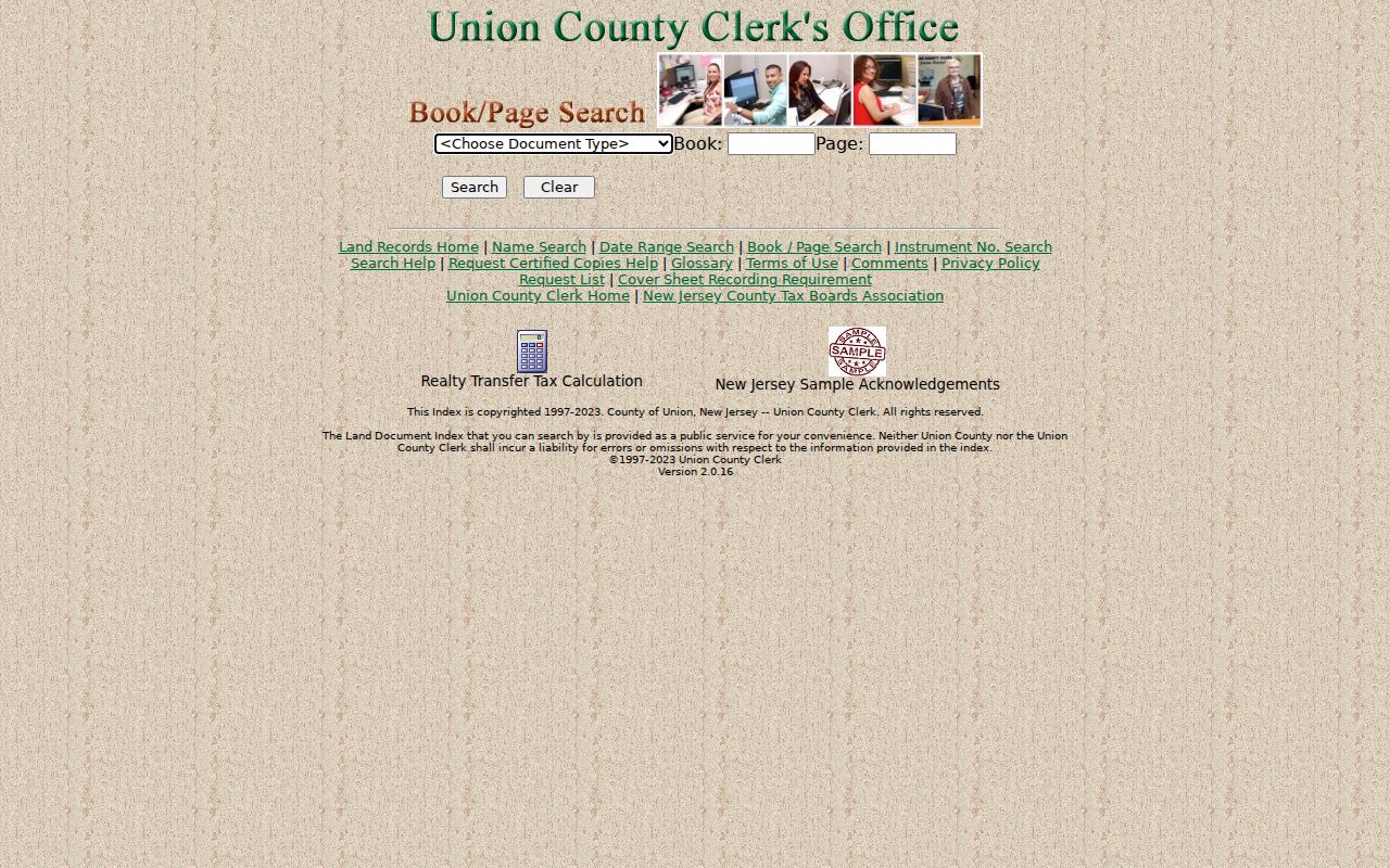
Book and page help reconnect a street title trail to older instruments when the researcher already has the record reference.
Hillside Street ZIP Labels
Postal geography helps normalize an address but does not define a Hillside street’s municipal boundary. ZIP 07205 is the only regular Hillside ZIP positively documented in the research. USPS also recognizes the Industrial Hillside station in the same ZIP. Nearby 07083, 07111, 07112, and 07208 belong to adjacent postal geography and must be checked address by address rather than treated as Hillside coverage.
Use the USPS ZIP lookup by address before a parcel search. Then use the municipality, county, block, and lot to establish the property record context. The deed index, voter portal, and GIS viewer were not verified as ZIP-wide resident directories. For ZIP-based searching, use the separate Hillside ZIP directory rather than substituting a postal label for parcel evidence.
Hillside Street Privacy Limits
A street property trail is not a household census. Renters, guests, children, unregistered residents, and protected people may not appear in tax or land records. A deed party can be a trust, entity, heir, or former owner. DMV address data, utility customer lists, delivery lists, and private membership rosters are not public street directories. An old numerical directory has a date and can be wrong or incomplete even for that date.
Daniel’s Law, the Address Confidentiality Program, court sealing, and voter protections can suppress an address or identity field. New Jersey’s stalking statute, N.J.S.A. 2C:12-10, prohibits conduct that creates reasonable fear. A record that is publicly accessible still must be used lawfully and with restraint.
Lawful use. Hillside street records support personal, family-history, property, and civic research; never use them to stalk, threaten, harass, or harm anyone.